

Florida Trail
My Florida Trail Hike
I hiked through Florida from Jan. 3, 2016 at Key West and hiking the Florida Keys Heritage Trail to Key Largo. Then, from the southern terminus of the Florida Trail north to Ocala, arriving on Jan. 27.
I took about 900,000 steps to hike about 450 miles.
My Gear
My pack weighs right around 18 pounds without food and water. It looks like I may carry up to 5 days of food and will resupply from stores rather than ship food to post offices.
The prices are only for costs of this trip. Almost all gear is still working well from previous treks, so see the IAT Hike page for costs. I'm not including Josh's gear because that's up to him.
| Item | Oz | $$ | Notes |
| G4 backpack | 16 | $0 | 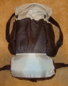 made myself from pattern. made myself from pattern.Comfortable, light, and plenty of room for all my gear. I'm still using my green version and it's holding up great, but I did need to shorten the waist straps since it is too loose after I hike a few hundred miles and lose weight. :-) |
| Sleeping | |||
| shelter | 27 | $0 | 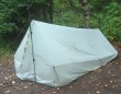 I'll use my silnylon shelter I made. This weight includes stakes, lines, and groundsheet. I treated it with silicone spray, added a bug screen edge and floor, and it works just fine. There are only 3 shelters on the FT, so I'll use this most nights (unless new friends I meet put me up for the night:-) ). Josh will use my Bear Paw Wilderness Designs La Garita shelter with Minimalist I bug net that weighs 28 oz. plus stakes. I switched to the Bear Paw shelter when Josh left the trail. I'll use my silnylon shelter I made. This weight includes stakes, lines, and groundsheet. I treated it with silicone spray, added a bug screen edge and floor, and it works just fine. There are only 3 shelters on the FT, so I'll use this most nights (unless new friends I meet put me up for the night:-) ). Josh will use my Bear Paw Wilderness Designs La Garita shelter with Minimalist I bug net that weighs 28 oz. plus stakes. I switched to the Bear Paw shelter when Josh left the trail. |
| sleeping quilt | 40 | $0 | 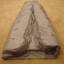 I made this quilt from a pattern for my AZT hike. We'll take both my lighter weight green version and this warmer one. When Josh left, I switched to the warmer quilt. I made this quilt from a pattern for my AZT hike. We'll take both my lighter weight green version and this warmer one. When Josh left, I switched to the warmer quilt. |
| Exped Synmat 7 UL Pad | 16 | $0 |  comfortable, warm, light mattress for restful nights. Josh gets a simple blue cell pad. comfortable, warm, light mattress for restful nights. Josh gets a simple blue cell pad. |
| Exped Schnozzel Pumpbag | 2.0 | $0 | 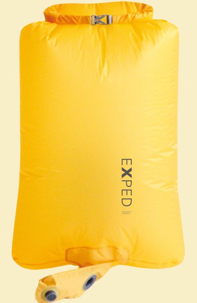 Fills pad quickly with dry cold air instead of hot moist breath, and keeps me from getting dizzy! Serves as food bag at night and storage for clothes in pack during day. Fills pad quickly with dry cold air instead of hot moist breath, and keeps me from getting dizzy! Serves as food bag at night and storage for clothes in pack during day. |
| Exped pillow | 2.7 | $0 | 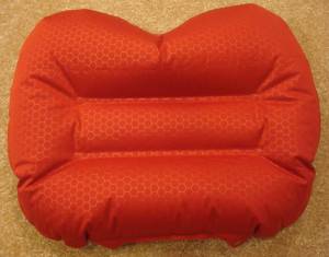 xmas present. xmas present.Pretty comfortable and worth the extra bit of weight. |
| Cooking | |||
| No cooking on this trip. | |||
| food | 1-9 lbs. | $0 | I will carry 5 days of food at the most. |
| Water | |||
| water filter | 4.2 | $0 | Sawyer Squeeze filter continues to work wonderfully. Water sources turned out to be no problem and got most water from potable sources, only filtering a few times. |
| water bottles | 1.2 | $0 | two .6L throw-out bottles - cheap, easy, light. |
| water | 2-6lb. | water is plentiful most of the time, so no need to carry much. 2.2lb/L | |
| Clothes | |||
| Orange Boonie hat | 3.5 | $1 | very visible on treacherous road walks and in hunting areas |
| BSA wicking t-shirt | 11.2 | $0 | light, synthetic. It refuses to wear out! |
| long sleeve nylon shirt | 12 | $0 | Wore this every day, for sun protection. |
| BSA zip-off pants | 17.2 | light and sturdy | |
| ArmaSkin socks | 1.2 | rubbery anti-blister socks. They worked fine in the swamp, but wore a hole through in just 2 days. | |
| Darntough socks | 2.9 | I got these on the A.T. and they seemed very nice, but I didn't get to wear them long enough. They are warm, soft, and sturdy. These socks were awesome! Wore them every day except 2 days in swamp. | |
| underwear | 2.8 | 2 pr. | |
| shoes | 32.5 | $20 | el cheapo from WalMart. Got them for practice hiking and they fit nice, so I'm going with them. They last about 300 miles before the soles wear through. |
| bandanna | 1.0 | $1 | too many uses to list here. |
| army surplus liner | 16.4 | $8 | cheap buy off eBay for a nice layer of insulation. |
| Electronics | |||
| cellphone | 4.4 | 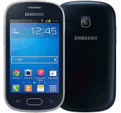 for daily blogs and pics. I now have a Samsung Galaxy Light. This will be my watch, alarm, phone, camera, gps. for daily blogs and pics. I now have a Samsung Galaxy Light. This will be my watch, alarm, phone, camera, gps. | |
| tracker | 4.2 | pings to satellite with my location. Batteries last about 10-14 days when on for 12 hours/day. | |
| headlamp | .5 | $0 | 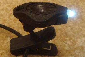 Awesome photon light. One set of batteries lasts about 10 days, but probably less on this hike since there will be less daylight hours. Awesome photon light. One set of batteries lasts about 10 days, but probably less on this hike since there will be less daylight hours. |
| batteries | 7.0 | $15 | I bought 3 extra cellphone batteries and a simple charger off eBay. It's a much lighter solution than a solar charger or battery pack. I just recharge a battery in my phone and one in the charger at the same time in a town. 12 AAA lithiums for tracker, and 12 CR2016 coin batteries for headlamp - purchased online for pennies. I'll have more mailed later, if needed. |
| FT App | 0.0 | $36 | For help with water sources and location. These apps are great tools and they weigh nothing. |
| Other | |||
| trek poles | 19 | $0 | 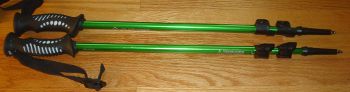 nearly worn out, but only needed for support in swamps and erecting shelter. nearly worn out, but only needed for support in swamps and erecting shelter. |
| pedometer | .6 | $0 | 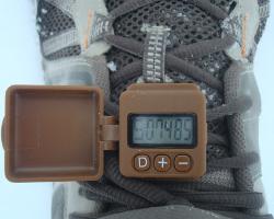 track my steps, just for fun. The great folks at GeoPalz gave me a replacement for the one I lost in the wilds of Wisconsin. track my steps, just for fun. The great folks at GeoPalz gave me a replacement for the one I lost in the wilds of Wisconsin. |
| rain poncho | 3.4 | $4 | cheap disposable to cover me and pack from rain - taking 2. |
| rain skirt | 2.0 | $1 | I saw people with these and they look like they work. Just a garbage bag cut open and cinched around waist. |
| guide | 16 | $28 | Florida Trail Guide. Heavy, so I threw pieces away as I finished sections. I never used it on the trail - just used the app. |
| 1st aid kit | 3 | basic personal items - bandaids, pain relief, tape, liquid skin, CPR mask, gauze pads, allergy meds, ... | |
| pad repair kit | .4 | ||
| compass | 1.1 | ||
| knife | 1.1 | tiny, single blade. | |
| toothbrush | 1.3 | includes paste | |
| ear plugs | 0 | I'm taking a bunch, just in case. | |
| 50ft. core | 1.5 | hanging food to protect from animals | |
| toilet kit | 2.8 | TP, Purell | |
| misc. | 12 | 2 garbage bags, whistle, clippers, thermometer, and other small items | |
| duct tape | 1.5 | Duct tape has many uses, but I'm taking bright orange this time so I can be seen in open hunting areas. Need to take more next time. | |
| stickers | 5 | Taking 100 Hiking Dude stickers to hand out to folks I meet. Got rid of about 70 of them! | |
| Total | ~19 lbs 4lbs worn, not in pack 15lb pack weight 4 to 11 lbs food & water 23 to 30 lbs - total weight | ||
My Food
I chose to not cook on this trip and that worked out just fine. Some restaurants and stops at convenience stores supplemented the menu that looked something like:
- Breakfast: 2 poptarts, 2 protein bars - 750 calories. I'm rarely hungry before starting my morning hike.
- Lunch: nutella on tortillas - 600 calories.
- Snacks: Austin crackers, peanut M&Ms, trail mix, sunflower kernels - 900 calories
- Dinner: protein powder after hiking and tuna or salmon on tortillas, Nutty Bar for dessert - 600 calories.
- Drink: just water. lots and lots of water.
- Daily vitamin
My Expenses
- travel to trailhead from home - $200 - fly to Ft. Lauderdale, rental car to Key West.
- travel from trailend to home - $103 - from Orlando
- gear - $20 shoes. Wore out first pair and bought replacements at Clewiston.
- guide and maps - $64
- food - $280
- lodging - $300 for 3 camping nights in Keys and hotel in Clewiston, Kissimmee, and Polk City
- Total - $900
Florida Trail Statistics
| States | Florida |
| Distance | 1500 miles - but this includes loop trails so a thru-hike is about 1,100 miles. Over 1,000 miles of trail are completed with connector routes between. When I complete the trail, I'll let you know how many steps it took me since I'll wear a pedometer the distance. |
| Total Elevation | The total cumulative elevation climbed is undocumented at this time but is extremely small since the entire trail is nearly flat. |
| Terminus | South: Big Cypress Oasis Visitor Center on Hwy 41 in Big Cypress National Preserve West: Fort Pickens |
| Highest Point | 270ft - Eglin AFB |
| Lowest Point | 1ft - Big Cypress National Preserve |
| Map |  |
| Terrain | Flat and often swampy. Follow orange blazes. |
| History | Conceived in 1964 by Jim Kern. Established as a National Scenic Trail in 1983. First thru-hiked by Steve Sheridan in 1989. |
| Challenges |
Feral dogs, big cats, bears, snakes, alligators. Swamps. |
| Time Window | November through April. Starting between Christmas and New Year's heading northbound takes advantage of the winter dry season and is when most thru-hikers tackle the trail. |
| Time to Hike | Typically takes 8 to 12 weeks. |
| Permits | Must join the Florida Trail Association to cross private property on trail segments. See FTA permit page for long list of special permit requirements. |
| Thru-hiker Tally | Around 150, recent years have seen about 15-20 thru-hikes completed. End to End Roster. Most hike northbound with the weather and to avoid hunting seasons. |
Trail Links
| Google Earth | View Trail with google earth |
| Full Maps | FTA Maps |
| Agencies | Florida Trail Association |
Land Managers and Partners of the Florida Trail
| Forest Service |
| Florida Forest Service |
| Partnership for the Nat'l Trails System |
All Comments:
Apr 07, 2015 - Molly
Jul 08, 2015 - Will
Jul 14, 2015 - Scott
Sep 14, 2015 - Rebecca
Oct 02, 2015 - Carolyn
Oct 03, 2015 - Hiking Dude
I'd really like to connect with someone to start the trail with, and hopefully do the whole thing. Since it's flat and lots of road, levy, dike walking I expect to average at least 25 miles a day. Slower in the swampy areas, but longer on dry flats.
If this sounds like something you'd be interested in, Send me Mail and we can chat more.
Oct 27, 2015 - Kellie
Nov 16, 2015 - jason
Nov 23, 2015 - Desiree
Nov 30, 2015 - Hiking Dude
FT Class of 2016 (most active), FT Hikers, Florida Trail, FT Association
Nov 30, 2015 - Hiking Dude
I've got Hiking Dude Stickers to hand out to folks I meet on the trail. Hope to see you out there!
Jan 02, 2016 - Mike Gormley
Jan 02, 2016 - Mike Gormley
Jan 03, 2016 - bren
I'm excited to read about this hike and daily adventures. Hope today is starting off great!
Jan 04, 2016 - Paul Geatches
Jan 05, 2016 - Hiking dude
@paul - it has been interesting so far! Walking through swamp will be an exciting adventure.
Jan 06, 2016 - Sue Standish
Jan 07, 2016 - Teena Gawler
Jan 10, 2016 - Tom Berg & Joy Klemp
Tom & Joy
Jul 07, 2016 - Nika Jane
Dec 25, 2016 - William Andrew Walton
Dec 25, 2016 - Colby
Cheers,
Colby
Jan 16, 2017 - Hiking Dude
There's a good chance you'll meet a thru-hiker or two during that time.
Ask a Question
Find more Hiking Resources at www.HikingDude.com
Follow Me
Recent Comments